HISTORY OF THE MARITIME HYDROGRAPHIC DIRECTORATE
Until 1882 the Romanian vessels used for navigation the Danube charts drawn by Russian specialists and nautical charts prepared by the British specialists. With the increase of the military ships transiting the Danube River and establishment of the Navy Children School, it was felt the need for drawing and using Romanian documents. In this respect, the Major (Navy) Mihail Drăghicescu, as Chief of Fleet Staff, ordered that during the training marches on the Danube and execution of students training practice on board the Romanian vessels, measurements on the Danube should be carried out in order to know precisely the channels of navigation and existing obstructions.
Thus, in 1882 and 1883 Major Mihail Draghicescu, the crews and students embarked on the Fulgerul and Lebada ships collected a rich material which, skillfully used by Draghicescu, led to the drawing of the first Romanian Danube chart. This chart was reproduced at the scale 1:28 000 in 1895 being constantly updated by the military crews during the execution of training marches on the Danube. This chart was used in very good conditions until 1904. In the years 1885-1886 it was carried out the first survey of the Romanian Black Sea coast, in the Sulina - Gura Portiţei area on board the “Griviţa” gunboat, in order to study the possibilities of entry into the lake Razelm.
Since 1893, a group of hydrographic and hydrological surveyors led by Grigore Antipa carried out several working campaigns on board the cruiser “Elisabeta”, the Brig “Mircea” and the gunboat “Griviţa”.

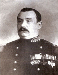
Major (Navy) Mihail DRAGHICESCU
The first hydrographic survey structure was the Special Section for the Hydrographic Works on the Danube River and Black Sea established in 1897 and led by Lieutenant Commander Alexandru Cătuneanu, hydrographic surveyor specialized in France and participant in two hydrographic campaigns in the Far East and Caledonia. On June 30, 1897 several officers were detached to the Special Section for hydrographic works which, under the command of Lieutenant Commander Alexandru Cătuneanu began to survey the Romanian coastline. The surveys were performed over a distance of 10 km of coastline, on the survey lines, at the distances of 2500 m from each other.

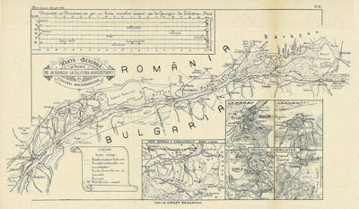
The First Romanian Danube Chart
In 1900, after a laborious activity of four years, based on the information from hydrographic and hydrological works executed with the Brig “Mircea” and the boat “Rahova”, it was drawn the first Romanian nautical chart, known as “Cătuneanu Chart”. This was printed in Paris in the same year, receiving the gold medal at the Universal Exhibition held in the French capital. Updated and reprinted in 1929, this chart was used by the Romanian Navy until 1952.
Also in 1900, on the occasion of the Romanian-Bulgarian border delimitation, the Romanian officers together with the inspector Kehaia D. carried out several hydrographic surveys on the Danube River, near Silistra - Gura Văii, on the basis of which it was performed a chart of the Danube at the scale 1:50 000 and another one of the islands, of the scale 1:20 000.
In 1904, a River Piloting and Hydrography Service of the Navy was established in Galaţi, within which a practical river piloting school operated.
On 23 February 1926, by the Ministerial Decision no. 126, issued under the provisions of the Navy Organization Law of 1898 and art. 1 of the Navy Operation Rules in 1912 the Maritime Hydrographic Service was established, with its headquarters in the building of the Naval School from Constanţa (currently the building housing the Museum of the Romanian Navy). During 1926-1940, the Maritime Hydrographic Service performed numerous specific actions of which the most important were: the execution of the hydrographic surveying at the Danube River mouth, the exploration to expand the port of Constanta, publication of the nautical charts at the scale 1: 50.000 in the Romanian seaside area.
Between 1940 and 1945, the Maritime Hydrographic Service has provided Navy with hydrographic and hydro-meteorological information.
Between 1945 and 1955, the Maritime Hydrographic Service has participated in the navigation waterways and coastline redevelopment and published over 20 new nautical charts, at different scales, for the west side of the Black Sea.
On 11 November 1955, by the Decision of the Council of Ministers of the R.P.R. no. 2444, the Maritime Hydrographic Service was reorganized in Maritime Hydrographic Directorate (MHD).
During 1955 - 1990, the MHD performed several actions of great diversity for the benefit of the Romanian military and civilian vessels to ensure navigation in the area of responsibility of Romania, of which the most important were: construction and commissioning of lighthouses Constanta (1960) and Sf. Gheorghe (1968), publication of the "Black Sea Pilot" and “Notices to mariners".

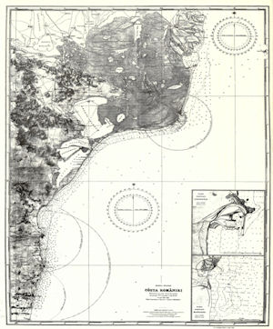
Catuneanu Chart
In 1966 MHD became the Romanian government representative as Member State of the International Association of Aids to Navigation and Lighthouse Authorities (IALA / AISM).
From 1971 to the present, MHD – a unique institution in the country, the main expert of Romania on matters concerning the maritime boundaries and maritime geography – participates with specialists in the National Inter-ministerial Committee for negotiations on the exclusive economic zone and continental shelf of the Black Sea delimitation.
In 1985 the International Hydrographic Organization allocated the first international serial number for a Romanian paper chart, the number INT 3820 to the Chart No. 1.300.01 The Black Sea, Coast of Romania From Nos Kaliakra to Danube Delta, scale 1:300 000, being printed the next year and included in 1993 in the International Charts Catalogue.
After 1990, the institution was reorganized and moved to its current headquarters, and made, among others: 37 national nautical charts, List of Lights and Fog Signals from Marmara and Black Seas and Nautical Tables.
In 2002, MHD developed the first Electronic Navigation Chart (ENC) in Romania.
During 2002 - 2003 the National Integrated Meteorological System of the Navy was created.
In 2004 the Official Gazette no. 941 published the Law no. 395 on maritime hydrographic activity, establishing and regulating the Maritime Hydrographic Directorate activity, granting also to the institution the status of national authority for this activity.
Since January 2007, MHD became the Romanian government representative as Member State of the International Hydrographic Organization (IHO).
Since 2008 MHD is accredited as an institution engaged in scientific research being involved in national and European funded projects.
In 2008 the Maritime Hydrographic Directorate participates with a cartographic specialist in the national delegation on maritime delimitation in the Black Sea at the International Court of Justice in The Hague, action related to the establishment and delimitation of the Black Sea continental shelf between Romania and Ukraine.
In 2010, following the votes of IHO MBSHC (Hydrographic Commission of the Mediterranean and Black Seas) members, the Maritime Hydrographic Directorate received the second INT number for a Romanian chart, the number INT3905 for the chart no. 1.030.02 The Black Sea, Coast of Romania - Constanta harbor and approaches, scale 1:30 000, chart included in the Catalogue of International Charts in 2010 and printed in 2014.
Since 2011, MHD issues the publication Notices to Mariners and the Cumulative List of Notices to Mariners in English and Romanian, allocating ISSN numbers from National Library of Romania for all periodical nautical publications of Notices to Mariners – monthly and annually. The acronyms have allocated too for all Romanian nautical publications by Maritime Hydrographic Directorate.
In 2012, MHD has become the 27th Member of the International Centre for Electronic Navigational Charts (IC-ENC).
In 2013, the first Romanian Electronic Navigational Chart, RO405002, has been validated and distributed by IC-ENC. This ENC is the equivalent to the Romanian paper chart no. 1.050.02 - The Black Sea, Coast of Romania From Cape Tuzla to Cape Midia.
MHD also edited 2 new publications – List of Lights and Fog Signals from Marmara and Black Seas (DH-103) and IALA Maritime Buoyage System (DH-104) as well as 4 military manuals including the technical specifications for issuing of the first 2 special naval charts in NATO style.
In 2015, the International Hydrographic Organization allocated other 2 INT numbers for 2 Romanian charts – INT3907 to chart no. 1.050.06, From Gura Sf. Gheorghe to Gura Musura, scale 1:50 000 and INT3908 to chart no. 1.030.09, The Port of Sulina and approaches, scale 1:30 000. The charts are included on the International charts Catalogue in the same year and were printed the next year. The first 2 special naval charts were elaborated in the same year together with another military manual with all technical specifications for all styles of NATO charts.
In 2016, IC-ENC validated and distributed 6 Romanian Electronic Navigational Charts, in 3 and 4 usage bands.
At the beginning of 2017, IC-ENC validated and distributed 8 Romanian Electronic Navigational Charts, in 4 and 5 usage bands.
At the end of 2019, 16 electronic navigation charts were validated by IC-ENC in 2, 4, 5 and 6 usage bands.
Starting with 2020, maritime navigation charts will have a QR code, and by scanning it, MHD site will be accessed and updates will be available for each map.
Until 1882 the Romanian vessels used for navigation the Danube charts drawn by Russian specialists and nautical charts prepared by the British specialists. With the increase of the military ships transiting the Danube River and establishment of the Navy Children School, it was felt the need for drawing and using Romanian documents. In this respect, the Major (Navy) Mihail Drăghicescu, as Chief of Fleet Staff, ordered that during the training marches on the Danube and execution of students training practice on board the Romanian vessels, measurements on the Danube should be carried out in order to know precisely the channels of navigation and existing obstructions.
Thus, in 1882 and 1883 Major Mihail Draghicescu, the crews and students embarked on the Fulgerul and Lebada ships collected a rich material which, skillfully used by Draghicescu, led to the drawing of the first Romanian Danube chart. This chart was reproduced at the scale 1:28 000 in 1895 being constantly updated by the military crews during the execution of training marches on the Danube. This chart was used in very good conditions until 1904. In the years 1885-1886 it was carried out the first survey of the Romanian Black Sea coast, in the Sulina - Gura Portiţei area on board the “Griviţa” gunboat, in order to study the possibilities of entry into the lake Razelm.
Since 1893, a group of hydrographic and hydrological surveyors led by Grigore Antipa carried out several working campaigns on board the cruiser “Elisabeta”, the Brig “Mircea” and the gunboat “Griviţa”.

Major (Navy) Mihail DRAGHICESCU
The first hydrographic survey structure was the Special Section for the Hydrographic Works on the Danube River and Black Sea established in 1897 and led by Lieutenant Commander Alexandru Cătuneanu, hydrographic surveyor specialized in France and participant in two hydrographic campaigns in the Far East and Caledonia. On June 30, 1897 several officers were detached to the Special Section for hydrographic works which, under the command of Lieutenant Commander Alexandru Cătuneanu began to survey the Romanian coastline. The surveys were performed over a distance of 10 km of coastline, on the survey lines, at the distances of 2500 m from each other.

The First Romanian Danube Chart
In 1900, after a laborious activity of four years, based on the information from hydrographic and hydrological works executed with the Brig “Mircea” and the boat “Rahova”, it was drawn the first Romanian nautical chart, known as “Cătuneanu Chart”. This was printed in Paris in the same year, receiving the gold medal at the Universal Exhibition held in the French capital. Updated and reprinted in 1929, this chart was used by the Romanian Navy until 1952.
Also in 1900, on the occasion of the Romanian-Bulgarian border delimitation, the Romanian officers together with the inspector Kehaia D. carried out several hydrographic surveys on the Danube River, near Silistra - Gura Văii, on the basis of which it was performed a chart of the Danube at the scale 1:50 000 and another one of the islands, of the scale 1:20 000.
Also in 1900, on the occasion of the Romanian-Bulgarian border delimitation, the Romanian officers together with the inspector Kehaia D. carried out several hydrographic surveys on the Danube River, near Silistra - Gura Văii, on the basis of which it was performed a chart of the Danube at the scale 1:50 000 and another one of the islands, of the scale 1:20 000.
In 1904, a River Piloting and Hydrography Service of the Navy was established in Galaţi, within which a practical river piloting school operated.
On 23 February 1926, by the Ministerial Decision no. 126, issued under the provisions of the Navy Organization Law of 1898 and art. 1 of the Navy Operation Rules in 1912 the Maritime Hydrographic Service was established, with its headquarters in the building of the Naval School from Constanţa (currently the building housing the Museum of the Romanian Navy). During 1926-1940, the Maritime Hydrographic Service performed numerous specific actions of which the most important were: the execution of the hydrographic surveying at the Danube River mouth, the exploration to expand the port of Constanta, publication of the nautical charts at the scale 1: 50.000 in the Romanian seaside area.
On 23 February 1926, by the Ministerial Decision no. 126, issued under the provisions of the Navy Organization Law of 1898 and art. 1 of the Navy Operation Rules in 1912 the Maritime Hydrographic Service was established, with its headquarters in the building of the Naval School from Constanţa (currently the building housing the Museum of the Romanian Navy). During 1926-1940, the Maritime Hydrographic Service performed numerous specific actions of which the most important were: the execution of the hydrographic surveying at the Danube River mouth, the exploration to expand the port of Constanta, publication of the nautical charts at the scale 1: 50.000 in the Romanian seaside area.
Between 1940 and 1945, the Maritime Hydrographic Service has provided Navy with hydrographic and hydro-meteorological information.
Between 1945 and 1955, the Maritime Hydrographic Service has participated in the navigation waterways and coastline redevelopment and published over 20 new nautical charts, at different scales, for the west side of the Black Sea.
On 11 November 1955, by the Decision of the Council of Ministers of the R.P.R. no. 2444, the Maritime Hydrographic Service was reorganized in Maritime Hydrographic Directorate (MHD).
During 1955 - 1990, the MHD performed several actions of great diversity for the benefit of the Romanian military and civilian vessels to ensure navigation in the area of responsibility of Romania, of which the most important were: construction and commissioning of lighthouses Constanta (1960) and Sf. Gheorghe (1968), publication of the "Black Sea Pilot" and “Notices to mariners".

Catuneanu Chart
In 1966 MHD became the Romanian government representative as Member State of the International Association of Aids to Navigation and Lighthouse Authorities (IALA / AISM).
From 1971 to the present, MHD – a unique institution in the country, the main expert of Romania on matters concerning the maritime boundaries and maritime geography – participates with specialists in the National Inter-ministerial Committee for negotiations on the exclusive economic zone and continental shelf of the Black Sea delimitation.
In 1985 the International Hydrographic Organization allocated the first international serial number for a Romanian paper chart, the number INT 3820 to the Chart No. 1.300.01 The Black Sea, Coast of Romania From Nos Kaliakra to Danube Delta, scale 1:300 000, being printed the next year and included in 1993 in the International Charts Catalogue.
After 1990, the institution was reorganized and moved to its current headquarters, and made, among others: 37 national nautical charts, List of Lights and Fog Signals from Marmara and Black Seas and Nautical Tables.
In 2002, MHD developed the first Electronic Navigation Chart (ENC) in Romania.
During 2002 - 2003 the National Integrated Meteorological System of the Navy was created.
In 2004 the Official Gazette no. 941 published the Law no. 395 on maritime hydrographic activity, establishing and regulating the Maritime Hydrographic Directorate activity, granting also to the institution the status of national authority for this activity.
Since January 2007, MHD became the Romanian government representative as Member State of the International Hydrographic Organization (IHO).
Since 2008 MHD is accredited as an institution engaged in scientific research being involved in national and European funded projects.
In 2008 the Maritime Hydrographic Directorate participates with a cartographic specialist in the national delegation on maritime delimitation in the Black Sea at the International Court of Justice in The Hague, action related to the establishment and delimitation of the Black Sea continental shelf between Romania and Ukraine.
In 2010, following the votes of IHO MBSHC (Hydrographic Commission of the Mediterranean and Black Seas) members, the Maritime Hydrographic Directorate received the second INT number for a Romanian chart, the number INT3905 for the chart no. 1.030.02 The Black Sea, Coast of Romania - Constanta harbor and approaches, scale 1:30 000, chart included in the Catalogue of International Charts in 2010 and printed in 2014.
Since 2011, MHD issues the publication Notices to Mariners and the Cumulative List of Notices to Mariners in English and Romanian, allocating ISSN numbers from National Library of Romania for all periodical nautical publications of Notices to Mariners – monthly and annually. The acronyms have allocated too for all Romanian nautical publications by Maritime Hydrographic Directorate.
In 2012, MHD has become the 27th Member of the International Centre for Electronic Navigational Charts (IC-ENC).
In 2013, the first Romanian Electronic Navigational Chart, RO405002, has been validated and distributed by IC-ENC. This ENC is the equivalent to the Romanian paper chart no. 1.050.02 - The Black Sea, Coast of Romania From Cape Tuzla to Cape Midia.
MHD also edited 2 new publications – List of Lights and Fog Signals from Marmara and Black Seas (DH-103) and IALA Maritime Buoyage System (DH-104) as well as 4 military manuals including the technical specifications for issuing of the first 2 special naval charts in NATO style.
In 2015, the International Hydrographic Organization allocated other 2 INT numbers for 2 Romanian charts – INT3907 to chart no. 1.050.06, From Gura Sf. Gheorghe to Gura Musura, scale 1:50 000 and INT3908 to chart no. 1.030.09, The Port of Sulina and approaches, scale 1:30 000. The charts are included on the International charts Catalogue in the same year and were printed the next year. The first 2 special naval charts were elaborated in the same year together with another military manual with all technical specifications for all styles of NATO charts.
In 2016, IC-ENC validated and distributed 6 Romanian Electronic Navigational Charts, in 3 and 4 usage bands.
At the beginning of 2017, IC-ENC validated and distributed 8 Romanian Electronic Navigational Charts, in 4 and 5 usage bands.
At the end of 2019, 16 electronic navigation charts were validated by IC-ENC in 2, 4, 5 and 6 usage bands.
Starting with 2020, maritime navigation charts will have a QR code, and by scanning it, MHD site will be accessed and updates will be available for each map.


